RESEARCH INSIGHT · DETERMINISTIC SYNTHETIC PLANNING · POC DIRECTION
搜尋機率,而不是只搜尋網格
Multi-UAV collaborative search—find sooner by searching where the probability moves.
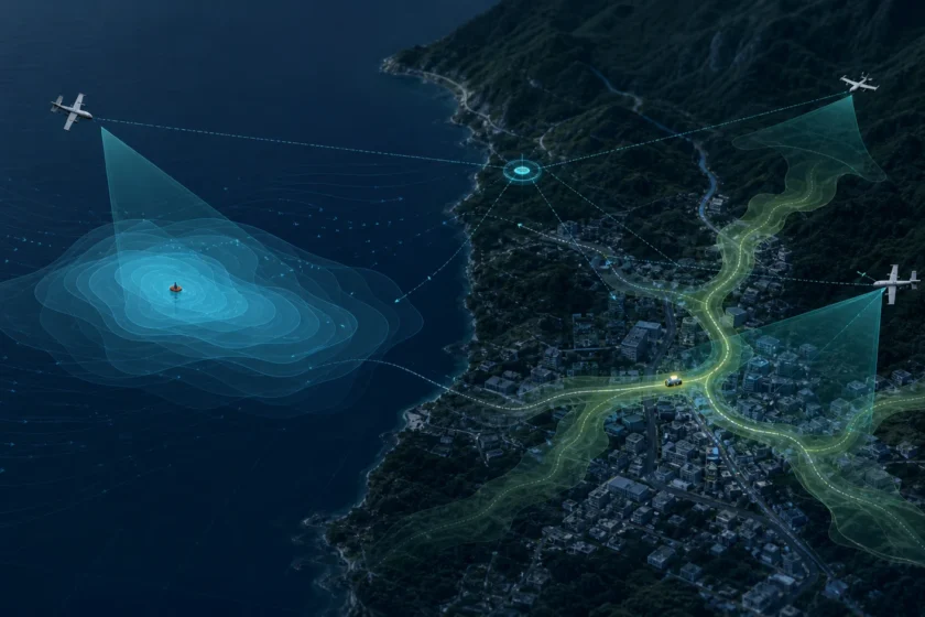
A person in the water does not remain at the last reported coordinate. A moving ground contact does not remain inside the square where it was first observed. In both cases, a search plan should follow a changing probability distribution—not treat the map as a static checklist.
Multiple heterogeneous UAVs share one evolving belief map, then divide search, second-view verification, relay and reserve roles as new evidence arrives.
The intended result is less time spent in low-probability areas, less duplicated coverage and more useful search per minute and per watt-hour. Comparative performance will be measured through repeatable benchmarks and partner POC work.
85-SECOND VISUAL WALKTHROUGH · MARITIME SEARCH
Watch the probability field change as evidence arrives.
The Resilience Mapper turns open geospatial, terrain, satellite and weather inputs into a changing search picture. It then assigns vehicles by sensor, endurance and link capability; updates the belief map after negative observations; and reallocates work when a node fails.
- One planning loop, different domain physics
- Camera field of view is not effective search width
- “Nothing found” can still be evidence
- Multiple aircraft should divide information, not only area
- Every credible pass should change the map
- More aircraft only helps when the airspace is deconflicted
- What exists today—and what remains POC work
- Evidence boundary
- Public references
One planning loop, different domain physics
Last-known information → probability field → sensor-aware routes → observations → updated belief → reassignment → replayable evidence.
At sea, a search object may move with surface current, tide, wind leeway and wave-driven uncertainty. Object type matters: a person, life jacket and raft do not drift in the same way.
On land, motion is constrained by roads, intersections, slopes, buildings, vegetation, off-road accessibility, stopping and turning behavior. SHEEPDOG keeps one evidence, sensor and coordination contract while loading different motion adapters for maritime and ground search.
Camera field of view is not effective search width
Altitude and lens geometry provide only a theoretical footprint. Useful search width also depends on target size, resolution, viewing angle, speed, stabilization, visibility, glare, sea state, occlusion and detector performance.
The planner should use the effective, evidence-backed footprint of each aircraft—not the largest rectangle that can be drawn under it.
“Nothing found” can still be evidence
A missed detection must never erase a hypothesis automatically. If a region was outside the camera frustum, hidden by a building, washed out by glare or observed with insufficient image quality, the absence of a detection says very little.
When a calibrated sensor clearly covers a predicted branch and reports no contact, that branch can be down-weighted. This distinction—between unobserved and observed-clear—is central to an honest search system.
Multiple aircraft should divide information, not only area
Equal-area partitioning is a useful baseline, but heterogeneous aircraft should not be treated as identical tiles. Launch position, speed, endurance, wind tolerance, sensor footprint, communications and recovery reserve all change which vehicle can search a region safely and in time.
Every reassignment should be explainable: what changed, which alternatives were considered, what constraint ruled them out, and what result followed.
Every credible pass should change the map
Two or three aircraft can revisit a high-value region from different angles, at different times or with different sensors. When each pass clearly covers the predicted location and still finds nothing, the posterior probability of that region should fall and the fleet can spend its next minute elsewhere.
Repeated passes are not automatically independent. The same glare, building shadow, low resolution or detector failure can hide the same target every time. SHEEPDOG therefore records the actual footprint and quality of each observation; a poor or occluded view does not earn the same negative-evidence weight as a clear one. Low-probability regions are deprioritized—not erased—and can rise again when drift, movement or new evidence changes the picture.
More aircraft only helps when the airspace is deconflicted
Crewed aircraft remain essential for long endurance, heavy sensors, command and physical rescue. Adding more of them, however, also adds operating and airspace-coordination cost. Small UAVs can make denser, repeatable and differently angled search passes more practical, but they do not remove collision risk.
A multi-UAV plan must separate flight intent across latitude, longitude, altitude and time, monitor conformance, preserve contingency routes and yield when crewed rescue aircraft enter. The search planner and the safety planner must be the same mission picture—not two disconnected screens.
What exists today—and what remains POC work
External research supports this system direction and informs the benchmark design. A 2026 Valun Bay field-trial paper integrated real-time drifter measurements, dynamic probability modeling, multi-UAV search control and machine vision—and also documented camera and radio-link failures. A 2025 ICUAS paper separately formulated probability-based search-effort allocation, energy-aware routing and potential collision handling for coordinated UAVs. These precedents inform the evaluation plan and integration roadmap.
The current deterministic research build contains inspectable ground probability branches derived from nearby road directions, negative-observation updates, a bounded maritime current/wind coast model, fixed-wing search geometry, sensor-handoff gates and replayable decision evidence.
Project SHEEPDOG is building the coordination and evidence layer that helps heterogeneous assets search a changing world—and makes every recommendation inspectable afterward.
Public references
Valun Bay UAV-supported maritime search field trials (2026) · Multi-UAV SAR effort allocation, ICUAS 2025 · Australian National Search and Rescue Manual · FAA UAS Traffic Management